
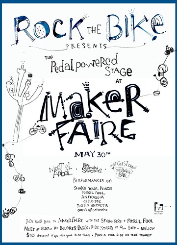
Maker Faire is welcoming bike people in a major way this year. They’re aiming to have bike parking that can handle up to 2000 bikes (up from 300 last year). They’re offering $15 adult tickets to folks who ride to the event. [Read on.]
You don’t need to be part of our Cruiser Ride to take advantage of this offer. You can ride from any location. Cash makes it easy. Go to the V.I.P. bike entrance at the West Lot.
Read our online proposal to Maker Faire from earlier this year.
Saturday:
12:30 — SHAKE YOUR PEACE! Bike touring band with great foot-stomping numbers. They’ll be joining us on the ride.
1:30 — Antioquia Afro-Columbian Progress Rock. They’ll be on the ride!
2:30 — McPuzo & Trotsky Whimsical duo with witty tunes.
3:00 — Justin Ancheta Reggae and Rock. Beloved San Francisco street performing band. Bike touring musician.
4:00 — Guella — SF-based, world/funk band.
5:00 — Cello Joe , Bike Touring, beatboxing Cellist. Will be joining us on the ride.
6:00 — Oona Garthwaite — A knockout voice, an electrifying performer, powerhouse songwriting. Not to be missed.
7:00 — Fossil Fool, The Bike Rapper
Sunday:
12:00 — Quinn Deveaux Classic front porch blues sound.
1:30 — Five Cent Coffee
2:30 — Street Beats
3:30 —Gomer Hendrix Experience
4:30 — Open Mike
5:00 — Fossil Fool
Meeting at 8:30AM and departing at 9:00, the ride is about 19 miles over mostly flat terrain, and we will take a leisurely pace, cruising with great music on our party bikes.
We’ll arrive at Maker Faire at approximately 11AM, plenty of time to set up our Pedal Powered Stage for the first band of the day.
Let us know you’re coming! RSVP by writing a comment on this page.
The route from San Francisco: We’ll be closely following the San Mateo County North South Bicycle Route. This is a flat route, which closely follows the Caltrain route. This route starts on Tunnel Avenue, then uses Bayshore Boulevard through Brisbane and then a series of different streets through South San Francisco to get the Delaware Street in San Mateo. It takes about 1.5 hours to ride this route at an easy pace.
Get a map of the route at: http://bikesiliconvalley.org/files/nsroute/nsroutemap.pdf
Note this is a schematic map to define the route, use with a good local street map if you are not familiar with this area.
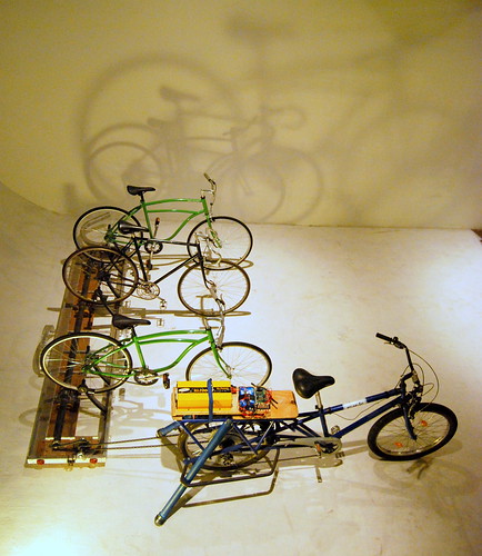
Our multi-person pedal power rig, the Biker Bar, will be supplying the bands with clean power to amplify their music.
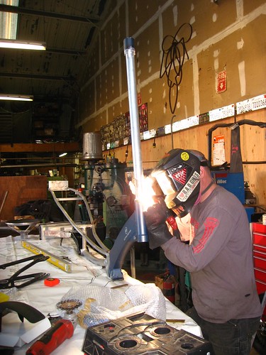
El Arbol will not be completed in time for this year’s Maker Fair, but the frame and kickstand are in progress, and you can check them out. If you’ve been designing a Soul Cycle (music bike) or Human Power application, bring your sketches down and get advice from Rock The Bike’s designers and engineers.
By train and bike. Use Caltrain or BART to cover most of the distance, and then bike the final leg. Bikes are allowed on Caltrain. Take your bike on board Caltrain and get off at the Hillsdale Station. BART allows bikes on board, however, not in the first car. Get off at the final Millbrae station. About a 30-40 minute ride to the Expo Center or board Caltrain for a connecting ride to the Hillsdale station. Exit on the west side of the station, the street directly in front of the west side of the station is California Avenue.
To ride go south on California, which becomes San Mateo Drive in San Mateo. At Tilton turn left, ride about 3 blocks on Tilton and the turn right on Delaware Street. Continue on Delaware for about 2 miles to the Expo Center. For information on using your bike on Caltrain and BART go to: http://www.bikesmc.org/id47.htm
From San Jose or the South Bay
Caltrain to the Hillsdale Station. Caltrain information at: www.caltrain.com
At the Hillsdale station, cross the platform and go down the steps to the parking lot (on the east side, you will see debris from the old Bay Meadows racetrack). Walk left (north) from the station along the fenced off bike/ped path north to the Expo Center. It is about a 10 minute walk.
Sam Trans (Bus)
Route 390 from Palo Alto. 40-minute ride from Palo Alto, Schedule at:http://www.samtrans.com/pdf/Schedules/Route_390_02-01-09.pdf
Santa Clara VTA Bus Service
Route 22 Runs from San Jose to Palo Alto where you could transfer to Samtrans. Route 22 schedule at:http://www.vta.org/schedules/SC_22.html
In San Mateo get off the bus as close to 25th Avenue as possible. Walk to 25th Avenue and walk east (toward the bay) and walk about 2 blocks to the Expo Center.
Note: We recommend using Caltrain for a faster, easier trip.
By Train and Bike
Ride to nearest Caltrain station (www.caltrain.com), take your bike on board. Get off at the Hillsdale Caltrain station and ride north to the Expo Center.
By Bike – To Ride to the Expo Center
For all San Mateo County cities south of San Mateo, we suggest the San Mateo County North South Road.Get a map of this route at:
http://bikesiliconvalley.org/files/nsroute/nsroutemap.pdf
Note this is a schematic map to define the route, use with a good local street map if you are not familiar with this area.
From Mountain View and Palo Alto
Starting in Mountain View (Castro Street) Go south on California Street
When California Street ends at Medio Avenue, turn left on Medio Ave.
Turn right on Miller Avenue. Follow Miller to a Bicycle/Pedestrian Bridge, which connects to Wilkie Way. Continue south on Wilkie Way to West Meadow Drive.
Turn right on West Meadow Drive.
Turn left on Bryant Street. Follow Bryant Street through Palo Alto.
If starting in Palo Alto start using Bryant Street. Bryant Street is an official bicycle boulevard and is a great street for bicycles.
When Bryant Street ends at Palo Alto Avenue, turn left. In about 1 block turn left on to the bicycle/pedestrian bridge to Willow Place. Turn right off Willow Place to Willow Road.
Then turn left onto Middlefield Road.
At this point you are on the San Mateo County North South Route. Use the map referenced above.
From Sawyer Camp Trail
At the south end of the trail, take Crystal Spring Road east (this road is directly opposite the gate at the south end of the trail). Turn left at the first stop sign on Crystal Springs Road. After a few miles, turn right at the stop sign at the four way intersection of Stonehedge on the left, and West Third Ave on the right. Turn right onto West Third Avenue. Follow West Third Ave through downtown San Mateo.
Turn right on Delaware Street and follow Delaware Street to the Expo Center
For a lower traffic route, turn right on Claremont Street (1 block before Delaware Street), then when Claremont ends at 16th Avenue turn left and to get back to Delaware Street.
From the East Bay
BART: Use Bart to the Millbrae station. At Millbrae transfer to Caltrain, ride Caltrain to the Hillsdale Station. Or take your bike on BART and ride from Millbrae station to the Expo Center. Or take BART to the Hayward Bart Station and take the AC transit M line bus. See AC Transit below.
AC Transit (Bus) runs their M line across both the San Mateo Bridge and the Dumbarton Bridges. These buses leave from Union City to cross the Dumbarton Bridge and Castro Valley and cross the San Mateo Bridge. Get off at the Hillsdale stop. The bus stops on El Camino Real at Hillsdale. Directly across El Camino Real is the Hillsdale Caltrain Station.
Walk to the station and then cross the tracks to get to the bike/pedestrian path on the east side of the tracks. Turn left (go north) for a short walk to the Expo Center. The bus connects to the Hayward BART station. Schedule at: http://www2.actransit.org/maps/schedule_results.php?version_id=7&quick_line=m&maps_line=m¤t_schedule=ALL
By Bike:
The AC transit M lines buses can carry up to six bikes, you could ride to catch this bus. Take this bus across the bay and get off at the Hillsdale stop. See directions above to get from the bus stop to the Expo Center.
The Dumbarton Bridge has a bike/pedestrian path on the south side of the bridge. After crossing the Dumbarton Bridge, follow the bike path to Willow, cross Bayfront Expressway to the bike trail on the east side (toward the Bay) which parallels Bayfront Expressway. Follow this bike trail (which is a section of the Bay Trail) north to Marsh Road. Turn left on Marsh Road and go west on Marsh over 101. Marsh Road ends on Middlefield. Turn right (north) on Middlefield. This is now the San Mateo County North South bicycle route, use the route referenced above to ride to the Expo Center.
Additional Information
511.org is a good source of Bay Area Transportation information.
There you can find links to all Bay Area transit providers.
BART: www.bart.gov
Samtrans: www.samtrans.com
Caltrain: www.caltrain.com
AC Transit: www.actransit.org
VTA (Santa Clara) www.vta,org
Information Provided by Bike San Mateo County www.bikesmc.org